CELTIC project UNICRINF

Maria Luisa Arranz
Nokia Spain
Maria_Luisa.Arranz_Chacon(at)nokia.com
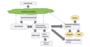
Major catastrophes demand efficient coordination and control of resources in order to ensure people’s safety. In the era of 5G and IoT, networks and applications play a fundamental role in monitoring and decision making in all areas involved. CELTIC project UNICRINF plans to use the available communications infrastructures to create a global integrated platform to monitor catastrophes, create ad-hoc communication infrastructures, communicate with emergency teams, and advise citizens.
Areas involved in a major catastrophe include emergency services, affected people, hospital resources, communications networks, infrastructure, and more. The fundamental objective during an emergency situation is the safety of the people. Technology should help and allow information to flow smoothly between all people involved.
Emergency scenarios and application domains
Emergencies come in different shapes – it could be an earthquake, a tsunami, a flood, a volcanic eruption, a toxic explosion, or a big fire. What all these disasters have in common is that they can compromise communications, which is vital for emergency services and affected people.
However, communications must also include the monitoring of the affected infrastructures, the contact with the people within the affected area regardless of the operator that serves them, the warning of the nearby population by all means available with action guidelines or the evacuation route of victims and available resources.
The UNICRINF project aims to facilitate effective disaster communication solutions covering a variety of scenarios and use cases, including:
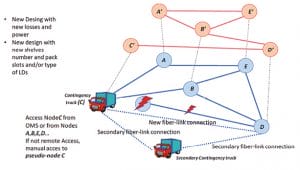
- Helping to up the part of the optical trunk network using a contingency truck that replaces the affected node as well as the priority services.
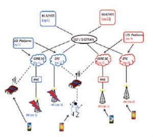
- Updating a local 5G or 4G VPN network using small cell or portable nodes
- Facilitating access to the internet and external servers through an ad-hoc satellite connection
- Performing a national pseudo roaming in order to have the affected people listed and located in the affected area regardless of the operator that serves them
Currently not even the geolocation is available in 112 calls as well as the broadcast of the same service.
- Allowing the transmission and reception of images taken by unmanned aerial, land or sea drones, both to the control centre and to people on the ground through augmented-reality glasses
- Multiscreen display in the control centre of the state of physical, human and image resources
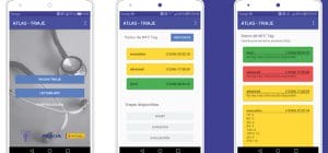
- Control of victims with digital triage and allocation of vehicular and hospital resources with online monitoring
- Traffic control by emergency services for greater fluidity in the evacuation of people and victims
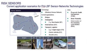
- Monitoring and control of damaged infrastructure and possible toxic spills (air or sea) through IoT sensors
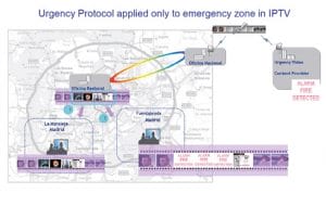
- Notice to the population of the affected area with action guidelines or evacuation orders
Information for emergency decisions
For correct decision making in an emergency situation, the state of the communications network, the acquisition of data and its presentation in a user-friendly way are important. Applications that facilitate the coordination and control of resources should be included and handled in a simple way. The collection and processing of data from sensor networks must be able to be filtered according to programmable criteria. There are many areas where current information to facilitate the resolution of problems from the control centre is required.


› Further information
- UNICRINF project page – https://www.celticnext.eu/project-unicrinf/
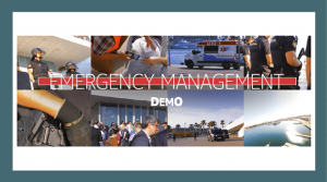
- Video of emergency communication demo – https://youtu.be/b2wFQ6eB6Zo