
Cicek Cavdar Mustafa Ozger Dominic Schupke
KTH Royal Institute of Technology KTH Royal Institute of Technology Airbus
Introduction
3D NETworks for 6G Mobile Communications Applications (3D-NET) project aims to position Europe’s next connectivity step as a true three-dimensional network rather than a loose coexistence of ground, air, and space systems. The project starts from a basic reality. Globally, nearly 2 billion people still have no access to mobile connectivity services, and only about 10% of the world’s landmass is covered by cellular or fibre infrastructure. Satellite systems can extend reach, but today they often depend on dedicated terminals, remain costly, and support only a limited number of users. At the same time, future services are becoming more demanding. Remote industrial control, emergency response, connected vehicles, aviation services, and autonomous systems all require connectivity that is continuous, reliable, and readily available.
This is why 3D-NET argues for a unified European architecture across terrestrial networks, non-terrestrial networks, and airspace platforms. The project is not simply about adding satellites to mobile networks. It is about creating a standard-compliant and validated communication fabric that can deliver service continuity from ground to sky for both human and machine-type users. In that sense, 3D-NET may serve for a broader European direction: seamless 3D connectivity as a foundation for future mobility, digital industry, and technological sovereignty.
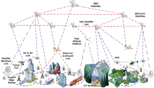
Figure 1. 3D-NET reference architecture across terrestrial with relevance also to selected maritime scenarios, as well as airspace, and non-terrestrial network domains, showing integrated links, platforms, and example application environments.
Architecture and use cases
The central idea of 3D-NET is architectural integration. Today’s terrestrial, aerial, and satellite systems are still designed, operated, and optimised too separately. That fragmentation becomes a serious problem when users move across domains or when the service is mission-critical. A drone or uncrewed aerial vehicles (UAV), flying beyond urban coverage, an aircraft requiring resilient broadband, or an industrial operation in a remote area cannot depend on disconnected technology islands. Figure 1 illustrates this integrated system context across ground, air, and space, combining satellites, high-altitude platforms, UAVs, terrestrial base stations, edge computing, and representative urban and rural scenarios.
3D-NET therefore proposes one 3D architecture with joint resource optimisation across ground, air, and space segments. It addresses not only radio access, but also orchestration, computing, caching, and service continuity. This creates a stronger basis for a wide range of use cases: broadband and IoT in remote regions, resilient communication for disaster and public safety scenarios, digital support for low-altitude economy services such as drones, helicopters and electric vertical take-off and landing aircraft (eVTOLs), and high-data-rate mobile services for users moving from ground to sky. In practical terms, the project frames connectivity as an end-to-end system problem rather than a single-link problem.
Mobility management from ground to sky
Mobility is one of the clearest areas where the need for a new model becomes visible. Classical mobility management was built for users moving on the ground between terrestrial cells. In 3D environments, however, users move not only horizontally but also vertically, across altitude layers, radio technologies, and even orbital segments. Aerial users often see many base stations at once, which can create unstable associations, unnecessary handovers, and service interruption.
Building on earlier work in CELTIC-NEXT project 6G-SKY project, 3D-NET takes this problem further by targeting seamless vertical and horizontal handovers across integrated terrestrial, airspace, and non-terrestrial domains. The aim is not only to reduce signalling overhead or handover failures. It is to sustain service availability for delay-sensitive and mission-critical applications, including live sensing, control traffic, and industrial operations. The project also creates room for learning-based mobility management, but with the understanding that future operational systems must be explainable, dependable, and compatible with standardisation and regulatory requirements.
Positioning, sensing and localisation
A second major contribution of 3D-NET is the convergence of communication with positioning and sensing. Future networks should not only transport data; they should also help devices understand where they are, what surrounds them, and how reliably they can act. This is especially important for autonomous or semi-autonomous systems operating in safety-critical environments.
The project therefore targets robust positioning, sensing, and localisation through integrated networks. This includes resilient navigation beyond conventional Global Navigation Satellite System (GNSS)-only operation, the use of low Earth orbit support, 6G mmWave systems, inertial sensing, vision, and multi-sensor fusion. At swarm level, localisation becomes both an individual and collective problem: each UAV must know its own position, while the swarm as a whole must maintain shared situational awareness. 3D-NET treats this as part of the network design itself. In parallel, integrated sensing and communication can strengthen localisation, tracking, and environment awareness, which is highly relevant for air traffic management, traffic monitoring, infrastructure inspection, and public safety.
Computing, caching and the Internet of Remote Things
3D-NET also expands the discussion beyond connectivity into distributed computing and service execution. Many future applications in remote or infrastructure-less areas will depend on where data is processed, how quickly it can be cached or forwarded, and how tasks are shared between edge, cloud, airborne platforms, and satellites. A network that only forwards bits is no longer sufficient.
For this reason, the project explicitly includes real-time and non-real-time computing and caching services. This is particularly important for the Internet of Remote Things, where sensing, control, and analytics must continue even in areas with weak or intermittent terrestrial coverage. The same applies to industrial and mobility applications in which response time, task offloading, and data freshness directly affect safety and performance. By addressing computing and caching together with communication, 3D-NET moves from a coverage-centric view to a service-centric one.
Energy efficiency, demonstrations and European relevance
A unified 3D system will only be credible if it is also sustainable. 3D-NET therefore treats energy efficiency as a cross-cutting design objective across the full ground-air-space continuum. The project is not looking for wider coverage at any cost. It is looking for scalable and realistic solutions that can balance coverage, performance, and resource use for operators, service providers, and vertical sectors. This matters not only for climate and operating cost, but also for the long-term viability of integrated 6G infrastructures.
To make this credible, 3D-NET plans technology demonstrations adapted to the maturity of the individual components and use cases. That is important because Europe does not need another abstract architecture paper alone. It needs validated solutions that can bridge research, industrial deployment, and standardisation. In this sense, 3D-NET builds directly on outcomes from 6G-SKY, BMBF 6G-TakeOff, and the Air Mobility Initiative. It also aligns with a wider European need for interoperable and sovereign capabilities across terminals, network software, airspace systems, and satellite communications. Within CELTIC-NEXT, 3D-NET can be seen as an important seed for a broader flagship strand on terrestrial, airspace, and non-terrestrial convergence.
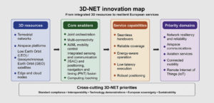
Figure 2. Proposed innovation map linking 3D-NET resources, enablers, capabilities, and priority application domains.
Conclusion
3D-NET is timely because it addresses a structural gap in current network evolution. The future challenge is no longer only how to increase peak rate in dense urban cells. The larger challenge is how to deliver continuous, trustworthy, and efficient services across heterogeneous environments, users, and infrastructures. Europe needs a connectivity model that supports future mobility, remote industry, resilient public services, and new digital business models without reinforcing fragmentation between ground, air, and space domains.
That is the strategic value of 3D-NET. It turns 3D connectivity from an aspirational slogan into an engineering agenda: one architecture, network resiliency, coordinated mobility, integrated positioning and sensing, distributed computing, energy-aware design, and standard-compliant demonstrations. If successful, it will help position Europe not only as a user of future 3D networks, but as a builder of them.
Outlook
The wider significance of 3D-NET is that it gives Europe a concrete way to organise several fast-moving trends under one technical and strategic framework. These trends include the low-altitude economy, multi-orbit satellite services, explainable and trustworthy AI for network control, resilient positioning beyond GNSS-only assumptions, and service continuity for industrial digitalisation outside urban hotspots. Instead of treating these as separate innovation threads, 3D-NET binds them into one programme logic.
This is also why the project matters beyond its own consortium. If Europe wants open, interoperable, and standard-driven solutions across chipsets, terminals, airspace systems, and network software, it needs integrative projects that connect research, demonstrations, and standardisation. 3D-NET is designed to play exactly that role. Figure 2 summarises this programme logic, showing how integrated 3D resources are translated into technical enablers, service capabilities, and priority European application domains.